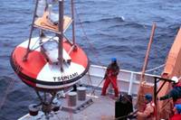
The U.S. has demonstrated the effectiveness of its warning system within the Pacific region. It has also demonstrated that the warning system can provide initial earthquake information to other nations and is most willing to share that information with all concerned. With national dissemination and water level networks in place, NOAA’s information can be used to mitigate future disasters.
Furthermore, the development of the Global Earth Observing System of Systems (GEOSS) led by the United States, Japan, South Africa and the European Commission—with 53 nations currently participating at the ministerial level—should help fill the sensor gap for other regions of the world. Two key focus areas of the GEOSS initiative are addressing "reducing loss of life and property due to disasters" and "monitoring our oceans."
NOAA is dedicated to enhancing economic security and national safety through the prediction and research of weather and climate-related events and providing environmental stewardship of the nation’s coastal and marine resources. NOAA is part of the U.S. Department of Commerce.
RELATED
- NOAA Pacific Tsunami Warning Center Bulletins and Map
- NOAA Tsunami Page
- Deep-ocean Assessment and Reporting of Tsunamis (DART)
- NOAA Water Level Observation Network
- NOAA and Tsunamis
- NOAA Tsunami Research Program
- NOAA TsunamiReady Communities are Prepared
- NOAA Tsunami Warning System Receives High Marks
- NOAA Leading the Way in Tsunami Research and Education


No comments:
Post a Comment